Trek Overview
Valley of Flowers Trek is one The Most Beautiful & Popular Monsoon Trek in Uttarakhand-2026
Valley of Flowers trek is indeed one of The Most Beautiful teak in uttrakhand. It is situated in the Chamoli district and is listed as a UNESCO World Heritage Site under the Criterion (vii) and Criterion (x). The covers 87 square kilometers, inhabited by numerous species of rare and endangered flora and fauna such as Blue Poppies, Brahmakamal, Cobra Lily, Primula, Asiatic Black Bear, Snow Leopard, Blue Sheep, musk bear, and brown bear to red fox, Himalayan birds etc.
"Think of the days when your eyes were glued to one of The Most Charming Valley of Uttarakhand, India during the monsoon season."
Valley of Flowers Trek Complete Guide
Our mission has always been to ensure that no trekker steps into the Himalayas without the right perspective. A trek is not just a checklist of summits; it is a serious commitment to the outdoors. Having the right information is what separates a reckless climb from a soulful journey.
This section serves as your definitive manual for the Valley of Flowers Trek. We have distilled years of mountain experience and real-time feedback into this guide to give you a clear, honest picture of the trail.
We provide this depth of information because we want you to be more than just a visitor—we want you to be a prepared, responsible trekker who respects the mountains as much as we do
Trek Itinerary
1: Short Itinerary
Overview: Trek summary at a Glance
Day 1– Pickup to you from Haridwar Drive to Govind Ghat via Rishikesh Devprayag, Rudraprayag, Joshimath (288 Km) (10/11 Hours) (1,875 m/ 6152 feet), Overnight Stay Hotel (Mode of transport by Tempo Travellers & Ertiga Taxi )
Day 2– After Breakfast Drive from Govindghat to Pulna by Local taxi (05 km -30 minutes drive), same day trek to Ghangaria (09 km) (5/6 Hours) (Altitude –10101 feet) Overnight Stay Hotel
Day 3– Trek from Ghangaria to Valley of flowers (10 km) Both Way (7/8 Hours) Altitude – 12140 feet back to Ghangaria Hotel-Overnight Stay Hotel
Day 4– Trek from Ghangaria to Hemkund Sahib (12 km) Both way (7/8 Hours) 14,100 feet) back to Hotel Overnight Stay Hotel
Day 5– Trek from Ghangaria to pulna road head 9 km /4/5 hours ) Same day driver to govind Ghat by local taxi (05km) 30 minutes)- After lunch if you intrested to visit Badrinath dham then take sharing taxi or tempo visit to Badrinath after darshan back to Hotel Govindghat – Overnight Stay Hotel
Note- Badrinath Sharing costs Rs. 500.00 both way per person pay to Directly your Driver
Day 6– Drive from Govindghat to Haridwar via Rishikesh by Taxi (288 km) (10/11 Hours) reach in the evening 7:00 pm. to 8:00 pm Haridwar Railway Station ((Mode of transport by Tempo Travellers & Ertiga Taxi )
2: Detailed Day-wise Itinerary
A Complete Route & Campsite Breakdown
Detailed Day-Wise Itineary - Day 1
Day 1 : Pickup from Haridwar Railway Station 6:00 am or Rishikesh 7:00 am and Drive to Govidghat (base camp) by Tempo Travllers
- Total distance – 288 km – 10/11 Hours journey
- Mode of journey – By Tempo Travellers
- Altitude – Govindghat– 6152 feet
- Night stay – Hotel – Share basis 3/4 trekkers per room
Trek Himalyan Soul organizes transport for trekkers from Haridwar Railway Station in the morning which will leave for Govindghat around 6:00 am to 6:30 am.
The drive from either Haridwar Railway Station or Rishikesh to Govindghat , serving as the base camp for various treks and pilgrimage sites in Uttarakhand, offers spectacular views of the Himalayan landscape, river valleys, and quaint mountain villages. Here’s what you can expect along the route:
- Departure from Haridwar or Rishikesh: Your journey begins in either Haridwar or Rishikesh, both of which are major towns in Uttarakhand and significant pilgrimage destinations. These towns are located on the banks of the Ganges River and offer a spiritual atmosphere with numerous temples, ghats, and ashrams.
- Travel along the Ganges River: As you leave Haridwar or Rishikesh, you’ll travel alongside the Ganges River for a significant portion of the journey. The river is a lifeline for the region, and you’ll witness locals engaging in various activities along its banks, from performing rituals to taking dips in its holy waters.
- Ascend into the Mountains: As you proceed towards Joshimath, you’ll gradually ascend into the Garhwal Himalayas. The road winds its way through dense forests, providing glimpses of towering peaks and cascading waterfalls. Keep an eye out for the diverse flora and fauna that inhabit the region, including Himalayan birds and wildlife.
- Crossing Confluence Points: Along the route, you may pass several confluence points where rivers merge. One notable confluence is Devprayag, where the Alaknanda River and Bhagirathi River meet to form the Ganges. These confluence points hold religious significance and offer stunning views of the merging rivers against the backdrop of the mountains.
- Scenic Villages and Towns: En route to Joshimath, you’ll pass through charming mountain villages and towns nestled amidst terraced fields and orchards. These villages offer a glimpse into the traditional lifestyle of the local Garhwali people and provide opportunities to interact with the friendly locals.
- Views of Nanda Devi Peak: On clear days, you may be treated to panoramic views of the majestic Nanda Devi Peak, which is the second highest mountain in India. The snow-capped peaks of the Nanda Devi range dominate the skyline and add to the beauty of the journey
Day -2
Day 2 : Drive from Govindghat to Pulna by Local taxi (05 km -30 minutes drive ,same day trek to Ghangaria
- Total distance – 09 km – 5/6 Hours journey
- Mode of journey – On foot
- Altitude Ghangaria – 10,101 feet
- Night Stay – Hotel – Share basis 3/4 trekkers per room
The trek from Govindghat to Ghangaria is part of the famous Valley of Flowers trek and the pilgrimage route to Hemkund Sahib in Uttarakhand, India. Here’s what you can expect along the trek route and the difficulty level:
- Trek Route: The trek from Govindghat Pulna Road head to Ghangaria covers a distance of approximately 09 kilometers. It follows a well-defined trail that ascends gradually along the Pushpawati River valley. The route passes through dense forests, charming mountain villages, and scenic meadows. Along the way, you’ll cross several suspension bridges over the river and encounter waterfalls, streams, and occasional grazing grounds.
- Difficulty Level: The trek from Govindghat to Ghangaria is considered to be of moderate . While the trail is well-marked and maintained, it involves a continuous ascent, which can be strenuous for some trekkers, especially if they are not accustomed to high-altitude hiking. The altitude gain from Govindghat (approximately 1,800 meters) to Ghangaria (approximately 3,050 meters) is significant, so it’s essential to pace yourself and take regular breaks to acclimatize.
- Terrain: The terrain along the trek route varies from rocky paths to dirt trails and wooden bridges. There are some sections with steep ascents, particularly as you approach Ghangaria. Additionally, depending on the time of year, you may encounter snow patches, especially in early summer months. Proper footwear with good grip is essential to navigate the terrain safely.
- Duration: The trek from Govindghat to Ghangaria typically takes around 6/7 hours to complete, depending on your pace and fitness level. It’s advisable to start early in the day to avoid hiking during the hottest hours and to allow plenty of time for rest breaks and enjoying the scenery along the way.
- Scenic Views: Despite the physical exertion, the trek offers breathtaking views of the surrounding mountains, including glimpses of towering peaks such as Neelkanth and Hathi Parvat. The lush greenery of the valley, dotted with colorful flowers during the monsoon season, adds to the beauty of the trek
Day - 3
Day 3 : Trek from Ghangaria to Valley of flowers
- Trek Distance – 10 km – 7/8 Hours journey
- Mode of journey – On foot
- Altitude – Valley of flowers – 12,140 feet
- Night Stay – Hotel -on Share basis 3/4 trekkers one Room
Today, you will be trekking to a World Heritage Site and National Park of Flowers. Post breakfast leave with packed lunch Ghangaria and come across the entry gate of the valley of flowers national park.
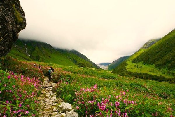
The trek from Ghangaria to the Valley of Flowers is the highlight of the Valley of Flowers trek in Uttarakhand, India. Here’s what you can expect along the route and the moderate level:
- Trek Route: The trek from Ghangaria to the Valley of Flowers covers a distance of approximately 04 to 5 kilometers one way. It follows a well-defined trail that ascends gradually through the valley. The route initially passes through forests and then opens up to the alpine meadows of the Valley of Flowers. Along the way, you’ll encounter numerous streams, waterfalls, and vibrant patches of wildflowers.
- Difficulty Level: The trek from Ghangaria to the Valley of Flowers is considered to be of moderate difficulty. While the trail is relatively short, it involves some steep sections and uneven terrain, particularly as you approach the valley. Additionally, the altitude gain from Ghangaria (approximately 3,050 meters) to the Valley of Flowers (approximately 3,600 meters) may cause breathlessness and fatigue, especially for those not acclimatized to high altitudes.
- Terrain: The terrain along the trek route consists of rocky paths, dirt trails, and wooden bridges. There are some sections with steep ascents and descents, as well as narrow passages. Proper footwear with good grip is essential to navigate the terrain safely, especially if the trail is wet or slippery due to rain or snowmelt.
- Duration: The trek from Ghangaria to the Valley of Flowers typically takes around 1.5 to 2 hours to complete one way, depending on your pace and the time spent exploring the valley. It’s advisable to start early in the day to avoid hiking during the hottest hours and to allow plenty of time for enjoying the scenery and photography opportunities in the valley.
- Scenic Views: The Valley of Flowers is renowned for its stunning natural beauty, with a kaleidoscope of colorful flowers carpeting the landscape during the monsoon season. As you trek through the valley, you’ll be surrounded by panoramic views of snow-capped peaks, lush greenery, and a myriad of flowers, including orchids, poppies, primulas, and more.
Day -4
Day 4 : Trek from Ghangaria to Hemkund Sahib 14,100 feet) back to Hotel
- Trek Distance – 12 km – 7/8 Hours journey
- Mode of journey – On foot
- Altitude – Hemkund Sahib Ji – 14,100feet
- Night Stay – Hotel – share Basis 3/4 trekkers one Room
The trek from Ghangaria to Hemkund Sahib is a challenging yet spiritually rewarding journey in the Uttarakhand region of India. Here’s what you can expect along the route and the difficulty level:
- Trek Route: The trek from Ghangaria to Hemkund Sahib covers a distance of approximately 06 kilometers one way. It is a steep ascent that gains altitude rapidly. The trail begins from Ghangaria and winds its way up the mountainside, passing through a series of switchbacks and stone-paved paths. As you ascend, you’ll pass through dense forests of pine and rhododendron, eventually reaching the alpine meadows and glacial landscapes near Hemkund Sahib.
- Difficulty Level: The trek from Ghangaria to Hemkund Sahib is considered to be of moderate to strenuous difficulty. The steep and continuous ascent, coupled with the high altitude, makes it challenging for many trekkers. The altitude gain from Ghangaria (approximately 3,050 meters) to Hemkund Sahib (approximately 4,300 meters) is significant and may cause symptoms of altitude sickness, such as shortness of breath, headache, and fatigue.
- Terrain: The terrain along the trek route consists of rocky paths, uneven terrain, and stone steps. There are sections with steep inclines, particularly in the latter part of the trek as you approach Hemkund Sahib. The trail can be slippery, especially if it has rained or snowed recently, so sturdy hiking boots with good grip are essential. Additionally, trekkers should be cautious while crossing streams and navigating narrow passages.
- Duration: The trek from Ghangaria to Hemkund Sahib typically takes around 3 to 4 hours to complete one way, depending on your pace and acclimatization. It’s advisable to start early in the day to avoid hiking during the hottest hours and to allow plenty of time for rest breaks and acclimatization stops. Trekkers should listen to their bodies and take breaks as needed to prevent altitude sickness and exhaustion.
- Scenic Views: Along the trek route, you’ll be treated to breathtaking views of the surrounding mountains, valleys, and waterfalls. As you ascend higher, the landscape transforms into alpine meadows dotted with colorful wildflowers during the summer months. The final stretch to Hemkund Sahib offers panoramic views of the glacial lake and the surrounding peaks, creating a serene and awe-inspiring atmosphere
Day -5
Day 5 : Trek from Ghangaria to Pulna Road head (09km) (4/5 hours)same day Drive to Govind Ghat Hotel (05km)
- Trek Distance – 09 km – 5/6 Hours journey (Drive 05 km) 20 minutes
- Mode of journey – On foot
- Night Stay – Hotel – share basis 3/4 Trekkers one Room
Trek from Ghangaria to Govind Ghat (9 kilometers): The trek from Ghangaria to Govind Ghat covers a distance of approximately 9 kilometers. It’s a descent from Ghangaria to Govind Ghat, so the terrain is generally easier than the ascent. The trail follows a well-marked path, and you’ll pass through the scenic landscapes of the valley, including forests, streams, and meadows. Depending on your pace, the trek can take around 3 to 4 hours to complete.
After lunch if you intrested to visit Badrinath dham then take sharing taxi or tempo visit to Badrinath after darshan back to Hotel Govindghat – Overnight Stay Hotel
Note- Badrinath Sharing costs Rs. 500.00 both way per person pay to Directly your Driver
Day -6
Day 6 : Drive from Govindghat to Haridwar via Rishikesh by Tempo Travellers
- Trek Distance –288 km – 10/11 Hours journey
- Mode of journey – By Tempo travellers
The drive from Govidghat to Haridwar via Rishikesh by Tempo Traveller offers stunning views of the Himalayan landscapes, river valleys, and charming towns along the way. Here’s what you can expect during the journey:
- Departure from Govindghat : Your journey begins in Govindghat , a bustling town located in the Chamoli district of Uttarakhand.
- Travel through the Garhwal Himalayas: As you leave Joshimath, you’ll travel through the Garhwal Himalayas, passing through picturesque mountain villages and dense forests. The road winds its way down the mountainsides, offering panoramic views of snow-capped peaks and verdant valleys.
- Passing through Chamoli and Rudraprayag: Along the route, you’ll pass through the towns of Chamoli and Rudraprayag, which are located at the confluence of rivers. These towns are known for their scenic beauty and spiritual significance, with numerous temples and shrines dotting the landscape.
- Arrival in Rishikesh: After descending from the mountains, you’ll arrive in Rishikesh, a vibrant town situated on the banks of the Ganges River. Rishikesh is renowned as the “Yoga Capital of the World” and attracts visitors from around the globe for its spiritual ambiance, ashrams, and adventure activities such as rafting and trekking.
- Exploring Rishikesh: Depending on your schedule, you may have some time to explore Rishikesh and visit its famous attractions, including the Triveni Ghat, Ram Jhula, and Laxman Jhula. You can also take part in yoga and meditation sessions or enjoy a stroll along the riverbank.
- Continuation to Haridwar: After exploring Rishikesh, your journey will continue to Haridwar, another sacred city located a short distance away. Haridwar is one of the holiest cities for Hindus and is known for its ghats, temples, and the nightly Ganga Aarti ceremony. The drive from Rishikesh to Haridwar is relatively short, taking around 30 minutes to 1 hour.
- Arrival in Haridwar: Upon reaching Haridwar, you’ll have the opportunity to witness the bustling activity along the ghats and soak in the spiritual atmosphere of this ancient city. You can attend the Ganga Aarti ceremony at Har Ki Pauri, explore the local markets, and visit the various temples and ashrams scattered throughout the city.can reach Rishikesh evening between 6 to 7 pm, or Haridwar 8:00 pm
3: Valley of flowers trek difficulty
Difficulty Level of Valley of Flower Trek
The altitude of the trek ranges from 3,858 meters to 4,572 meters, which is a stunning trek in the Indian Himalayas, located in Uttarakhand. Himalayas Valley of Flowers Trek It’s known for its beautiful views of the Nanda Devi , Badrinath Valley , Govidghat, Bhundiyar valley, Hemkund shahib Ji and Trishul peaks and is a popular trek for those looking to experience the beauty of the Himalayas
You have to travel 580 kms from Haridwar to Govindghat/ Joshimath and return Govindghat/ Joshimath to Haridwar/Rishikesh by Trek Himalyan Soul Transport Tempo Travellers and Taxi
The Valley of Flowers Trek Total Distance is 47 kms on foot from Pulna Road Head to Valley of Flowers Trek The altitude of the trek ranges from 3,858 meters to 4,572 meters, which Valley of Flowers Trek is considered moderate to Difficult Trek. It’s not as tough as some of the more challenging Himalayan treks, but it’s also not a walk in the park.
If you’re new to trekking, it can feel demanding, especially since the trek takes you to The altitude of the trek ranges from 3,858 meters to 4,572 meters, which The altitude might cause mild symptoms of altitude sickness, such as headaches or shortness of breath.
The trek typically lasts for about 05 nights 06 days, with an average of 6-8 hours of trekking per day. If you’re in good shape and can handle 6-8 hours of walking with breaks, you should be fine.
Valley of Flowers and Hemkund Trek Altitude
The trek takes you to a significant altitude (3,858 meters to 4,572 meters), so altitude sickness can be a concern, especially for beginners. You may experience symptoms like dizziness, headache, or nausea if your body isn’t used to higher altitudes.
To mitigate the risk, trek operators usually allow for acclimatization days, where you can rest at lower altitudes to help your body adjust
Hydration and eating well are also essential to avoid altitude sickness. Trek Himalyan Soul provide you proper food and all cooking your camp Hot and well food
Our Tips for Trekkers
- Start Slow: Don’t rush. Take frequent breaks to avoid exhaustion, especially when you're ascending.
- Hydrate & Eat Well: Drink plenty of water and eat energy-packed foods like nuts, dry fruits, and chocolate.
- Mental Preparedness: Stay positive, as trekking at higher altitudes can be mentally taxing.
Whenever you are going for any trek, it is very important that you go completely fit and ready. The trek is not difficult, if you make your feet and your mind calm and strong, you will find the trek very easy. While trekking, keep in mind that you are walking on the right route or not always with your guide.
If any trekkers have any more problems, then they are brought back to the base camp by laying them on the stretcher. Our camp in Kuari Pass trek is around the tree line where you can not have any problem with oxygen In case of any medical problem, the help of your guide or well-informed trekkers should be take
4: Best time to visit valley of flowers
Overview: Seasonal Weather
Seasonal Guide: Valley of Flowers, Hemkund Sahib & Badrinath
1. June: The "Early Bird" Season
- Valley of Flowers: Opens June 1st. You’ll see melting glaciers and snow bridges, but very few flowers (mostly Primulas).
- Hemkund Sahib: The trail often has high snow walls (10-15 ft). It is visually stunning but physically demanding.
- Badrinath: Very crowded due to the peak Char Dham Yatra season.
- Verdict: Best for snow lovers and those who want to avoid the monsoon rains.
July to August: The "Peak Bloom" Season (Top Choice)
- Valley of Flowers: This is the Gold Standard. The valley is in full bloom with over 300 species (Blue Poppies, Orchids, Lilies).
- Hemkund Sahib: The rare Brahma Kamal blooms around the holy lake. The weather is misty and spiritual.
- Badrinath: The "Shravan" month attracts devotees, but the monsoon keeps the casual tourist crowds thinner than in June.
- Challenges: Heavy rainfall and potential landslides. High-quality waterproof gear is a must.
- Verdict: The best time for photographers, nature lovers, and botanists.
3. September: The "Clear Skies" Season
- Valley of Flowers: The flowers begin to wither, and the valley turns a beautiful autumnal golden-brown.
- Hemkund Sahib: The lake is crystal clear, and the surrounding peaks are visible. Very peaceful.
- Badrinath: Excellent weather. The monsoon clouds clear up, offering magnificent views of the Neelkanth Peak.
- Verdict: Best for trekkers who prefer clear trekking paths, blue skies, and zero rain.
Month-wise Weather & Visibility
| Month | Avg. Temp | Rainfall | Flower Status | Badrinath Crowd |
|---|---|---|---|---|
| June | 10°C - 20°C | Low | Budding / Snow Bridges | Very High |
| July | 13°C - 19°C | High | Peak Bloom | Moderate |
| August | 13°C - 18°C | High | Peak Bloom | Moderate |
| September | 7°C - 15°C | Low | Fading / Golden Meadows | High |
Best Time for – July to September Travel Guide
This Trek is great for those people who have a great passion for mountaineering, Those who love flowers very much, who feel their fragrance and consider it a special purpose in their life.
We are the local people who are doing this trek for the monsoon season, we have every experience related to this trek. The right time to do this trek is from 25th June to the last week of August. When you come here inside this valley, you get lost here with flowers painted in color, this is a very wonderful and memorable moment for you.
Optional Detour: Seeking Blessings at Badrinath Temple
Not everyone takes this turn, but if you have a little extra time — and space in your heart — a visit to Badrinath Temple is totally worth it. It’s around 2 hours from Govindghat, and the road winds beautifully through the mountains alongside the Alaknanda river. The temple feels timeless — calm, powerful, and surrounded by snow peaks. You don’t need to be deeply religious to feel something there. And the best part? You don’t have to plan much. Just let your hotel or driver know, and for around ₹500 per person, they’ll arrange a direct ride. Simple, smooth, and honestly, a beautiful way to add soul to your mountain journey
5: Packing and Gear list
Essential Trek Gear List for the Valley of Flowers Trek
1. Trekking Gear & Bags
- Main Backpack (50–60 Liters): Must have a high-quality Rain Cover.
- Daypack (20 Liters): Mandatory. You will leave your main bag at the Ghangaria guesthouse and carry only essentials to the Valley.
- Trekking Poles: Essential for the steep stone-paved ascent to Hemkund Sahib.
2. Clothing (The Monsoon Layering System)
- Rainwear: A high-quality Poncho is better than a raincoat here, as it covers you and your backpack.
- Base Layer (2-3 Pairs): Quick-dry synthetic t-shirts. Avoid cotton as it won't dry in the humid monsoon air.
- Mid Layer: One light fleece jacket. It gets chilly at Ghangaria (base camp) at night.
- Outer Layer: A light windcheater or padded jacket for Hemkund Sahib ($4,329\text{m}$).
- Trekking Pants (2): Quick-dry, water-resistant material.
3. Footwear & Socks
- Trekking Boots: Waterproofing is non-negotiable. Ensure they have deep lugs (Grip) for slippery, wet stones.
- Floaters/Sandals: To wear at the guesthouse so your boots can dry.
- Socks: 4 pairs of synthetic/sports socks. Carry extra in case your feet get wet on the trail.
4. Headwear & Accessories
- Sun Cap: The mountain sun is harsh between rain showers.
- Woolen Cap: For the cold winds at Hemkund Sahib.
- Waterproof Gloves: One pair to keep hands dry and warm.
- Plastic Bags/Dry Bags: To double-wrap your electronics and spare clothes inside your bag.
Must-Have Medicines (VOF Edition)
- Knee Support/Braces: The descent from Hemkund Sahib is very steep and hard on the knees.
- Anti-Fungal Powder: Essential to prevent "trench foot" or fungal infections from wet feet.
- Pain Relief: Volini spray for calf muscles.
- Altitude Meds: Diamox (after consulting a doctor) for the steep climb to Hemkund Sahib.
- Digestive Care: Pudin Hara or Digene for stomach upsets.
Mandatory Document Checklist for VOF Trek
Note: Since VOF is in the same region as Kuari Pass, the forest permits are handled similarly by Trek Himalyan Soul in Ghangaria Check Post before entering valley of flowers Trek.
- Government ID Proof: Original + 2 Photocopies (Aadhar, Voter ID, or Passport).
- Trek Insurance: Mandatory for high-altitude trekking.
- Disclaimer Form: The standard indemnity bond provided by Trek Himalyan Soul at the base camp, Govindghat.
Quick Tips for Valley of Flowers
Start Early: Entry to the Valley opens at 7:00 AM. Starting early gives you more time to explore "Pushpawati River" banks before the afternoon rain clouds roll in.
Offloading: If you have back issues, you can hire a mule/porter from Govindghat to Ghangaria, but mules are not allowed inside the actual Valley of Flowers.
Mobile Network: Only BSNL and Jio work reliably in Ghangaria. Don't expect data; inform your family beforehand
Frequently Asked Questions
what is the valley of flowers trek ?
where the valley of flower located ?
Trek Fee
Complete Package from Rishikesh to Rishikesh
Extra Notes
Ethics, Health & Safety
Safety Over Summit: The mountain will always be there, but your safety is irreplaceable. Knowing when to turn back due to weather or health is the mark of a true trekker.
Respect the Altitude: Above 10,000 ft, your body follows its own rules. Prioritize acclimatization and consistent hydration; never ignore the early signs of altitude sickness.
Mountain Ethics (Leave No Trace): Carry your trash back. We are guests in the wilderness ensure the trails remain as pristine as you found them.
Trust the Experts: Local guides understand the mountain’s temperament better than any map. Follow their advice—it is based on years of survival and experience.
Physical Readiness: A trek is a physical commitment. Arriving fit ensures that you don't just endure the trail, but actually enjoy the journey
Trek Information
- Difficulty: Moderate
- Duration: 6 Days / 5 Nights
- Altitude: 12,140 feet
- Distance: 34 Kms
- Region: Uttarakhand
- Basecamp: Govindghat
- Accommodation: Tents/Hotel
- Suitable For: 8 to 65 years
- Cloakroom: Available
- Offloading: Available